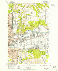
1950 Map of Spokane NE
USGS Topo · Published 1955About this map
Felts Field, the municipal airport, sits along the Spokane River in an era of rapid industrial and rail expansion northeast of the city. The landscape is dominated by a complex network of transportation, including the Great Northern and Union Pacific railroads, which service industrial pockets like Parkwater and Yardley. Further north, the terrain transitions from the developed grids of Hillyard to the agricultural expanses of Orchard Prairie and Pleasant Prairie. Notable institutional landmarks include the Mt St Michael Scholasticate overlooking the valley and the Edgecliff Sanitarium to the south. This survey also documents local community hubs like the Hutton Settlement and the Sekani Boy Scout Camp, alongside numerous neighborhood schools such as Arlington Sch and Orville C Pratt Sch, illustrating the postwar suburban growth between Spokane and the Spokane Valley.
Find a feature on this map
82 named features on this map. Tap any name to fly to it.
Don’t see what you’re looking for? This feature index may not catch every label — zoom into the map to look around manually.
Map Details
Editions of this 1950 Spokane NE Map
2 editions found
Other maps of this area

1901 · Spokane
USGS Topo · 1:125,000

1943 · Mt Spokane
USGS Topo · 1:62,500

1949 · Deer Park
USGS Topo · 1:62,500

1949 · Greenacres
USGS Topo · 1:62,500

1950 · Spokane NE
USGS Topo · 1:24,000

1950 · Spokane SE
USGS Topo · 1:24,000

1950 · Mt Spokane
USGS Topo · 1:62,500

1950 · Spokane SW
USGS Topo · 1:24,000

1950 · Spokane NW
USGS Topo · 1:24,000

1950 · Spokane
USGS Topo · 1:62,500