
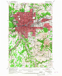
1950 Map of Spokane
USGS Topo · Published 1955About this map
The Spokane River serves as the industrial and geographic anchor of this mid-century landscape, where massive rail yards and sprawling educational campuses define the urban core. The dominance of the Great Northern and Northern Pacific railroads is evident, servicing the Magnesium Plant and the growing suburbs of Hillyard and Dishman. To the north and south, the transition from city to agricultural plateaus is marked by institutional landmarks like the Mt St Michael Scholasticate on Orchard Prairie and the Holy Cross Cem near Country Homes.
Find a feature on this map
148 named features on this map. Tap any name to fly to it.
Don’t see what you’re looking for? This feature index may not catch every label — zoom into the map to look around manually.
Map Details
Editions of this 1950 Spokane Map
2 editions found
Other maps of this area

1901 · Spokane
USGS Topo · 1:125,000

1903 · Oakesdale
USGS Topo · 1:125,000

1905 · Oakesdale
USGS Topo · 1:125,000

1943 · Mt Spokane
USGS Topo · 1:62,500

1943 · Medical Lake
USGS Topo · 1:62,500

1944 · Clayton
USGS Topo · 1:62,500

1949 · Deer Park
USGS Topo · 1:62,500

1949 · Greenacres
USGS Topo · 1:62,500

1950 · Spokane NE
USGS Topo · 1:24,000

1950 · Spokane SE
USGS Topo · 1:24,000