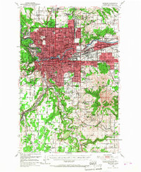
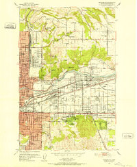
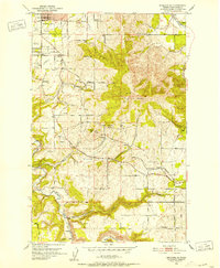
1950 Map of Spokane
USGS Topo · Published 1968About this map
Spokane River serves as the industrial and logistical spine for this mid-century portrait of Eastern Washington's urban hub. The cityscape is defined by a dense network of major railways, including the Great Northern RR and Northern Pacific RR, which converge near Spokane and the heavy industrial corridor through Hillyard. To the east, the sprawling growth of Dishman and Millwood follows the river valley, where landmarks like Felts Field and an Oil Refinery signal the era's economic expansion.
Find a feature on this map
154 named features on this map. Tap any name to fly to it.
Don’t see what you’re looking for? This feature index may not catch every label — zoom into the map to look around manually.
Map Details
Editions of this 1950 Spokane Map
2 editions found

Other maps of this area

1901 · Spokane
USGS Topo · 1:125,000

1903 · Oakesdale
USGS Topo · 1:125,000

1905 · Oakesdale
USGS Topo · 1:125,000

1943 · Mt Spokane
USGS Topo · 1:62,500

1943 · Medical Lake
USGS Topo · 1:62,500

1944 · Clayton
USGS Topo · 1:62,500

1949 · Deer Park
USGS Topo · 1:62,500

1949 · Greenacres
USGS Topo · 1:62,500
1950 · Spokane NE
USGS Topo · 1:24,000
1950 · Spokane SE
USGS Topo · 1:24,000