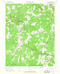
1966 Map of Spotsylvania
USGS Topo · Published 1968About this map
The Fredericksburg-Spotsylvania National Military Park dominates the northwest quadrant of this landscape, preserving the hallowed ground of the Civil War. Defensive positions and harrowing landmarks of the 1864 campaign are clearly identified, including the Battle Trench and the Bloody Angle. Nearby, the Confederate Cem and the Robert E Lee Sch in Spotsylvania anchor the local community's historical identity. Beyond the preserved battlefields, the mid-1960s terrain is defined by the winding paths of the Ni River, Po River, and Mat River. Evidence of early industry and infrastructure remains at Smiths Mill and the Gayle Mill Sta (Ruins) Bridge. Small settlements like Leavells, Fraziers Gate, and Thornburg are connected by a network of rural routes including Brock Road and Old Courthouse Road, illustrating the intersection of historic preservation and modern Virginia growth.
Find a feature on this map
35 named features on this map. Tap any name to fly to it.
Don’t see what you’re looking for? This feature index may not catch every label — zoom into the map to look around manually.
Map Details
Editions of this 1966 Spotsylvania Map
4 editions found
Other maps of this area

1887 · Spottsylvania
USGS Topo · 1:125,000

1889 · Fredericksburg
USGS Topo · 1:125,000

1892 · Fredericksburg
USGS Topo · 1:125,000

1892 · Spottsylvania
USGS Topo · 1:125,000

1894 · Fredericksburg
USGS Topo · 1:125,000

1926 · Stafford
USGS Topo · 1:62,500

1931 · Stafford
USGS Topo · 1:62,500

1942 · Woodford
USGS Topo · 1:31,680

1942 · Guinea
USGS Topo · 1:31,680

1942 · Ladysmith
USGS Topo · 1:31,680