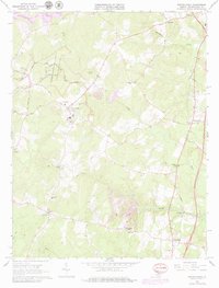
1966 Map of Spotsylvania
USGS Topo · Published 1979About this map
The Fredericksburg-Spotsylvania National Military Park dominates the northwestern portion of this 1966 survey, preserving the physical history of the Civil War. Numerous labels for a Battle Trench, Trench, and Ruins are interspersed among modern roads like Brock Road and Gordon Road. The map provides a detailed view of the Spotsylvania courthouse area, including the Confederate Cemetery and Robert E Lee School.
Find a feature on this map
39 named features on this map. Tap any name to fly to it.
Don’t see what you’re looking for? This feature index may not catch every label — zoom into the map to look around manually.
Map Details
Editions of this 1966 Spotsylvania Map
4 editions found
Other maps of this area

1887 · Spottsylvania
USGS Topo · 1:125,000

1889 · Fredericksburg
USGS Topo · 1:125,000

1892 · Fredericksburg
USGS Topo · 1:125,000

1892 · Spottsylvania
USGS Topo · 1:125,000

1894 · Fredericksburg
USGS Topo · 1:125,000

1926 · Stafford
USGS Topo · 1:62,500

1931 · Stafford
USGS Topo · 1:62,500

1942 · Woodford
USGS Topo · 1:31,680

1942 · Guinea
USGS Topo · 1:31,680

1942 · Ladysmith
USGS Topo · 1:31,680