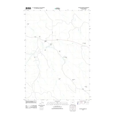
2012 Map of Spotted Horse
USGS Topo · Published 2012About this map
Spotted Horse stands as a focal point in this portion of Campbell County, where the high plains landscape is defined by an intricate network of seasonal drainages and creek beds. The drainage pattern is notably dense, with features like Rucker Draw, Store Draw, and Chicken Creek Draw carving through the terrain toward the larger Spotted Horse Cr. This 2012 survey illustrates the importance of water management in this arid environment, evidenced by the Endgate Reservoir situated just south of the main settlement area. Connectivity across these divides is maintained by routes like Werner Rd, which traverses the hills near Chicken Creek Divide. The naming conventions of the landscape, including L X Bar Cr and Sorenson Draw, reflect a long-standing history of ranching and land use in this part of Wyoming, where named draws and creeks served as vital landmarks for navigation and property boundaries.
Find a feature on this map
18 named features on this map. Tap any name to fly to it.
Don’t see what you’re looking for? This feature index may not catch every label — zoom into the map to look around manually.
Map Details
Editions of this 2012 Spotted Horse Map
This is the sole edition of this map. No revisions or reprints were ever made.
Other maps of this area

1954 · Gillette
USGS Topo · 1:250,000

1955 · Gillette
USGS Topo · 1:250,000

1958 · Gillette
USGS Topo · 1:250,000

1962 · Gillette
USGS Topo · 1:250,000

1971 · Larey Draw
USGS Topo · 1:24,000
1971 · Reservoir Creek
USGS Topo · 1:24,000
1971 · Kline Draw
USGS Topo · 1:24,000

1971 · Wildcat
USGS Topo · 1:24,000
1971 · Homestead Draw SW
USGS Topo · 1:24,000

1971 · Recluse
USGS Topo · 1:24,000