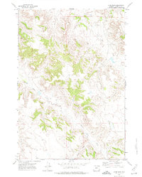
1971 Map of Kline Draw
USGS Topo · Published 1974About this map
Spotted Horse Creek and its tributary, the South Fork Spotted Horse Creek, carve a branching drainage pattern through this portion of Campbell County. The landscape is defined by the winding paths of Kline Draw and Dry Creek, reflecting the arid drainage network characteristic of the Powder River Basin. This early 1970s survey documents the intersection of natural topography and industrial exploration, noted by several instances of Oil Well and Drill Hole sites scattered across the township lines. These features indicate the active energy development occurring in the region during this era, as surveyors mapped the land's surface while industry probed beneath it.
Find a feature on this map
6 named features on this map. Tap any name to fly to it.
Don’t see what you’re looking for? This feature index may not catch every label — zoom into the map to look around manually.
Map Details
Editions of this 1971 Kline Draw Map
This is the sole edition of this map. No revisions or reprints were ever made.
Other maps of this area

1954 · Gillette
USGS Topo · 1:250,000

1955 · Sheridan
USGS Topo · 1:250,000

1955 · Gillette
USGS Topo · 1:250,000

1958 · Gillette
USGS Topo · 1:250,000

1958 · Sheridan
USGS Topo · 1:250,000

1962 · Gillette
USGS Topo · 1:250,000

1962 · Sheridan
USGS Topo · 1:250,000

1971 · Larey Draw
USGS Topo · 1:24,000
1971 · Reservoir Creek
USGS Topo · 1:24,000

1971 · Cabin Creek SE
USGS Topo · 1:24,000