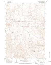
1971 Map of Spotted Horse
USGS Topo · Published 1975About this map
Spotted Horse and its surrounding drainage systems define the rugged high plains of Campbell County in the early 1970s. This survey reveals a landscape etched by intricate watercourses, notably Spotted Horse Creek and Chicken Creek, which carve through the arid terrain. The presence of numerous Wells and Drill Holes scattered across the land indicates active petroleum or mineral exploration, a hallmark of Wyoming's rural economy during this period. The terrain is divided by a prominent geographic Divide, with dozens of named features like L X Bar Creek and Rose Washout Draw documenting the localized naming conventions of ranchers and early settlers. From the northern reaches of New Deal Draw to the southern expanse of Highline Draw, the map captures a functional landscape where topography dictates the placement of unimproved roads and resource extraction sites.
Find a feature on this map
25 named features on this map. Tap any name to fly to it.
Don’t see what you’re looking for? This feature index may not catch every label — zoom into the map to look around manually.
Map Details
Editions of this 1971 Spotted Horse Map
This is the sole edition of this map. No revisions or reprints were ever made.
Other maps of this area

1954 · Gillette
USGS Topo · 1:250,000

1955 · Gillette
USGS Topo · 1:250,000

1958 · Gillette
USGS Topo · 1:250,000

1962 · Gillette
USGS Topo · 1:250,000

1971 · Larey Draw
USGS Topo · 1:24,000
1971 · Reservoir Creek
USGS Topo · 1:24,000
1971 · Kline Draw
USGS Topo · 1:24,000

1971 · Wildcat
USGS Topo · 1:24,000
1971 · Homestead Draw SW
USGS Topo · 1:24,000

1971 · Recluse
USGS Topo · 1:24,000