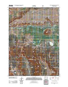
2011 Map of Sprague River East
USGS Topo · Published 2011About this map
The Sprague River meanders across this Klamath County landscape, a vital water source that defined the local development of ranching and settlement. Located near the Fremont Rd corridor, the community of Yainax Agency and the nearby Rock Creek Cemetery serve as important historical markers of the area's tribal and pioneer heritage. The terrain transitions from the high Knot Tableland in the northeast down toward the seasonal marshlands of Dams Meadow and Cliney Flat to the south.
Find a feature on this map
48 named features on this map. Tap any name to fly to it.
Don’t see what you’re looking for? This feature index may not catch every label — zoom into the map to look around manually.
Map Details
Editions of this 2011 Sprague River East Map
This is the sole edition of this map. No revisions or reprints were ever made.
Other maps of this area

1889 · Klamath
USGS Topo · 1:250,000

1894 · Klamath
USGS Topo · 1:250,000

1955 · Klamath Falls
USGS Topo · 1:250,000

1956 · Calimus Butte
USGS Topo · 1:62,500

1957 · Swan Lake
USGS Topo · 1:62,500

1958 · Klamath Falls
USGS Topo · 1:250,000

1960 · Beatty
USGS Topo · 1:62,500

1960 · Fuego Mountain
USGS Topo · 1:62,500

1980 · Williamson River
USGS Topo · 1:100,000
1985 · Sprague River West
USGS Topo · 1:24,000