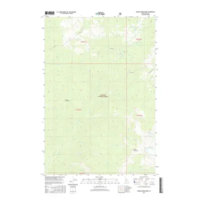
2017 Map of Spread Creek Point
USGS Topo · Published 2017About this map
The Nez Perce National Forest dominates this high-altitude landscape in central Idaho, where drainage networks like Bargamin Cr and Spread Cr carve through deep Idaho County terrain. This 2017 survey documents a wilderness defined by its named peaks and glacial water bodies, notably Spread Creek Point and the high-elevation Upper Trilby Lake. The transportation pattern relies on historic corridors like the Nez Perce Trail Rd and Montana Rd, which follow ridgelines and creek beds rather than established settlements. Several smaller lakes, including Bleak Cr Lake and Spread Point Lake, dot the southeastern portions of the quadrangle. These features, along with Grouse Creek Point, provide a detailed record of the geography as it exists within the federally protected forest boundaries, illustrating a landscape where nature and traditional trail routes remain the primary markers of place.
Find a feature on this map
31 named features on this map. Tap any name to fly to it.
Don’t see what you’re looking for? This feature index may not catch every label — zoom into the map to look around manually.
Map Details
Editions of this 2017 Spread Creek Point Map
This is the sole edition of this map. No revisions or reprints were ever made.
Other maps of this area

1956 · Elk City
USGS Topo · 1:250,000

1960 · Elk City
USGS Topo · 1:250,000

1966 · Green Mtn.
USGS Topo · 1:24,000

1966 · Three Prong Mountain
USGS Topo · 1:24,000

1966 · Sable Hill
USGS Topo · 1:24,000

1977 · Boston Mtn
USGS Topo · 1:24,000

1978 · Spread Creek Point
USGS Topo · 1:24,000

1978 · Dennis Mtn
USGS Topo · 1:24,000

1978 · Hida Point
USGS Topo · 1:24,000

1978 · Sheep Hill
USGS Topo · 1:24,000