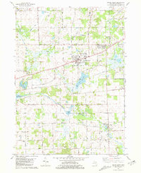
1981 Map of Spring Arbor
USGS Topo · Published 1981About this map
Spring Arbor and the surrounding township appear here in the late 1970s, characterized by a mix of educational institutions and rural landscapes. The map detail highlights Western High Sch and Bean Sch, alongside community focal points like The Kings Chapel and Spring Arbor Cem. To the south, the settlement of Horton sits near the winding course of the North Branch Kalamazoo River.
Find a feature on this map
32 named features on this map. Tap any name to fly to it.
Don’t see what you’re looking for? This feature index may not catch every label — zoom into the map to look around manually.
Map Details
Editions of this 1981 Spring Arbor Map
This is the sole edition of this map. No revisions or reprints were ever made.
Other maps of this area

1919 · Springport
USGS Topo · 1:62,500

1919 · Rives Junction
USGS Topo · 1:62,500

1921 · Rives Junction
USGS Topo · 1:62,500

1921 · Springport
USGS Topo · 1:62,500

1935 · Jackson
USGS Topo · 1:48,000

1939 · Jackson
USGS Topo · 1:62,500

1948 · Spring Arbor
USGS Topo · 1:62,500

1949 · Spring Arbor
USGS Topo · 1:62,500

1958 · Grand Rapids
USGS Topo · 1:250,000

1961 · Grand Rapids
USGS Topo · 1:250,000
Featured Places
- Spring Arbor Township, MI
- Spring Arbor, Spring Arbor Township
- Horton, MI
- Cross Mills, Spring Arbor Township
- Hanover Township, MI