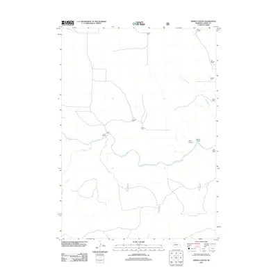
2011 Map of Spring Canyon
USGS Topo · Published 2011About this map
The Niobrara River winds through this section of Cherry County, cutting a deep valley through the Nebraska Sandhills. This 2011 survey documents a remote ranching landscape where land ownership and local history are marked by family-named landmarks. The river is joined by Medicine Creek and crossed by the Hook Bridge near the Ewart Ranch. Significant topographic relief is visible in Spring Canyon and Styre Canyon as they drain toward the river. The map records several established operations including the Stevens Ranch, McClaran Ranch, and F Hinton Ranch, alongside the Old Scholtes Ranch. This spatial record is essential for understanding the late 20th and early 21st-century distribution of these expansive Nebraska agricultural holdings.
Find a feature on this map
15 named features on this map. Tap any name to fly to it.
Don’t see what you’re looking for? This feature index may not catch every label — zoom into the map to look around manually.
Map Details
Editions of this 2011 Spring Canyon Map
This is the sole edition of this map. No revisions or reprints were ever made.
Other maps of this area

1950 · Powderhorn Valley
USGS Topo · 1:62,500

1950 · Cody
USGS Topo · 1:62,500

1950 · Doughboy
USGS Topo · 1:62,500

1952 · Eli
USGS Topo · 1:62,500

1952 · Doughboy
USGS Topo · 1:62,500

1957 · Valentine
USGS Topo · 1:250,000

1959 · Valentine
USGS Topo · 1:250,000

1985 · Heath Valley
USGS Topo · 1:24,000

1985 · Eli SE
USGS Topo · 1:24,000
1985 · Cody East
USGS Topo · 1:24,000