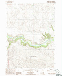
1985 Map of Spring Canyon
USGS Topo · Published 1985About this map
The Niobrara River carves a deep, winding valley through the Sandhills of Cherry County, creating a sharp contrast between the riparian corridor and the surrounding upland plateaus. This mid-1980s survey documents a landscape defined by large-scale ranching and federal land management, with the southern portion of the map dedicated to the Samuel R McKelvie National Forest. The map captures the infrastructure of these remote operations, including the Morton Administrative Site and several family-named outposts such as the McClaran Ranch and the H Hinton and F Hinton ranches.
Find a feature on this map
15 named features on this map. Tap any name to fly to it.
Don’t see what you’re looking for? This feature index may not catch every label — zoom into the map to look around manually.
Map Details
Editions of this 1985 Spring Canyon Map
This is the sole edition of this map. No revisions or reprints were ever made.
Other maps of this area

1950 · Powderhorn Valley
USGS Topo · 1:62,500

1950 · Cody
USGS Topo · 1:62,500

1950 · Doughboy
USGS Topo · 1:62,500

1952 · Eli
USGS Topo · 1:62,500

1952 · Doughboy
USGS Topo · 1:62,500

1957 · Valentine
USGS Topo · 1:250,000

1959 · Valentine
USGS Topo · 1:250,000

1985 · Heath Valley
USGS Topo · 1:24,000

1985 · Eli SE
USGS Topo · 1:24,000
1985 · Cody East
USGS Topo · 1:24,000