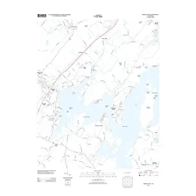
2013 Map of Spring City
USGS Topo · Published 2013About this map
Watts Bar Lake dominates the eastern half of this Tennessee landscape, its intricate shoreline creating a complex network of inlets, peninsulas, and islands such as Barker Island and Doc Smith Island. Along the western edge of the reservoir, the community of Spring City serves as a hub, flanked by specialized sites like the Spring City Dock and the nearby Rhea Springs Fish Hatchery. The map reveals a transition from the low-lying lakefront to the higher elevations of the Cumberland Plateau to the west, marked by significant natural features including Upper Piney Falls and Lower Piney Falls.
Find a feature on this map
207 named features on this map. Tap any name to fly to it.
Don’t see what you’re looking for? This feature index may not catch every label — zoom into the map to look around manually.
Map Details
Editions of this 2013 Spring City Map
This is the sole edition of this map. No revisions or reprints were ever made.
Other maps of this area

1887 · Kingston
USGS Topo · 1:125,000

1891 · Kingston
USGS Topo · 1:125,000

1893 · Kingston
USGS Topo · 1:125,000

1935 · Rockwood
USGS Topo · 1:24,000

1935 · Evensville
USGS Topo · 1:24,000

1935 · Decatur
USGS Topo · 1:24,000

1935 · Pennine
USGS Topo · 1:24,000

1936 · Roddy
USGS Topo · 1:24,000

1936 · Spring City
USGS Topo · 1:24,000
1936 · Grassy Cove
USGS Topo · 1:24,000