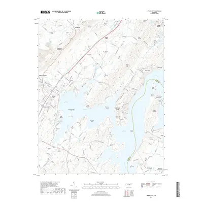
2019 Map of Spring City
USGS Topo · Published 2019About this map
Watts Bar Lake dominates this landscape along the Tennessee River, flooding the lowlands between the Cumberland Escarpment and Hampton Ridge. The town of Spring City sits at the base of the Walden Ridge foothills, where the Piney River and Vans Creek converge. The intricate shoreline of the reservoir is marked by numerous peninsulas and islands, such as Fooshee Peninsula and Doc Smith Island, reflecting a landscape profoundly altered by mid-century river management.
Find a feature on this map
174 named features on this map. Tap any name to fly to it.
Don’t see what you’re looking for? This feature index may not catch every label — zoom into the map to look around manually.
Map Details
Editions of this 2019 Spring City Map
This is the sole edition of this map. No revisions or reprints were ever made.
Other maps of this area

1887 · Kingston
USGS Topo · 1:125,000

1891 · Kingston
USGS Topo · 1:125,000

1893 · Kingston
USGS Topo · 1:125,000

1935 · Rockwood
USGS Topo · 1:24,000

1935 · Evensville
USGS Topo · 1:24,000

1935 · Decatur
USGS Topo · 1:24,000

1935 · Pennine
USGS Topo · 1:24,000

1936 · Roddy
USGS Topo · 1:24,000

1936 · Spring City
USGS Topo · 1:24,000
1936 · Grassy Cove
USGS Topo · 1:24,000