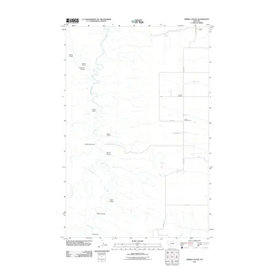
2011 Map of Spring Coulee
USGS Topo · Published 2011About this map
Arrow Creek and Coffee Creek carve a series of deep drainage channels across this Montana landscape, where the naming of topographic depressions—or coulees—reveals a history of local family settlement and land use. From Wilson Coulee in the northwest to Big Coulee in the south, these features define the arid terrain between large agricultural operations. The map documents the enduring presence of the Evers Ranch and the P N Ranch, which represent the large-scale ranching tradition of Fergus County. Along Everson Rd, a small cluster of social and civic life is preserved through the Everson Community Hall and the Everson Cemetery, marking a quiet center for a dispersed rural community.
Find a feature on this map
22 named features on this map. Tap any name to fly to it.
Don’t see what you’re looking for? This feature index may not catch every label — zoom into the map to look around manually.
Map Details
Editions of this 2011 Spring Coulee Map
This is the sole edition of this map. No revisions or reprints were ever made.
Other maps of this area

1953 · Starve Out Flat
USGS Topo · 1:24,000

1953 · Last Chance Bench
USGS Topo · 1:24,000

1954 · P N Ranch
USGS Topo · 1:24,000

1954 · Lewistown
USGS Topo · 1:250,000

1959 · Lewistown
USGS Topo · 1:250,000

1964 · Wolf Creek Falls
USGS Topo · 1:24,000

1964 · Spring Coulee
USGS Topo · 1:24,000
1978 · Soda Spring Coulee
USGS Topo · 1:24,000

1978 · Wild Bill Flat West
USGS Topo · 1:24,000
1978 · Steele Lake Coulee
USGS Topo · 1:24,000