
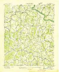
1935 Map of Spring Creek
USGS Topo · Published 1935About this map
The French Broad River carves through the northeast corner of this 1935 survey, where the Southern Railway meets the small settlement of Barnard. Higher in the mountains, the Appalachian Trail follows the high ridges of Hot Springs Mountain and Stony Spur. The landscape is defined by its rural community centers, featuring a high density of country churches and schools like Zion Ch, Balm Grove Ch, and Highland Sch that served families in the isolated hollows. Of particular historical interest is the Sandy Bottom Ferry, a pedestrian crossing over the river near Sandy Bottom, illustrating the localized transportation network before modern bridge infrastructure dominated Madison County. These features, alongside the Mine Company on Rocky Branch, reveal a self-sufficient mountain economy built around river access and timbered slopes.
Find a feature on this map
93 named features on this map. Tap any name to fly to it.
Don’t see what you’re looking for? This feature index may not catch every label — zoom into the map to look around manually.
Map Details
Editions of this 1935 Spring Creek Map
This is the sole edition of this map. No revisions or reprints were ever made.
Other maps of this area

1894 · Asheville
USGS Topo · 1:125,000

1901 · Asheville
USGS Topo · 1:125,000

1935 · Paint Rock
USGS Topo · 1:24,000

1935 · Hot Springs
USGS Topo · 1:24,000

1935 · Lemon Gap
USGS Topo · 1:24,000

1936 · Marshall
USGS Topo · 1:24,000

1936 · Sandymush
USGS Topo · 1:24,000

1936 · White Rock
USGS Topo · 1:24,000

1936 · Hepco
USGS Topo · 1:24,000
1936 · Leicester
USGS Topo · 1:24,000