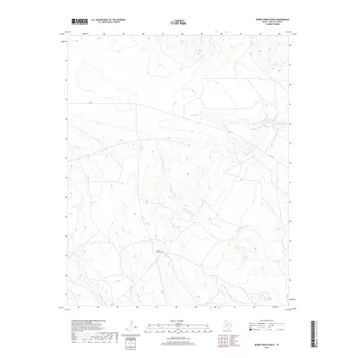
2019 Map of Spring Creek Ranch
USGS Topo · Published 2019About this map
Spring Creek Ranch serves as a central landmark in this portion of Hartley County, where the landscape is defined by a network of drainage systems and vital water resources. The geography is shaped by the intermittent flows of Romero Cr and its significant tributary, the W Fork Romero Cr, which carve paths through the high plains terrain. Local water management is evident through features like Buttermilk Tank and the specifically named Martha Houghton Lake Number 3, reflecting the region's reliance on captured surface water for ranching operations. Modern transit through this cattle country is facilitated by FM 767, which cuts across the northern and eastern sections of the quadrangle. The map also records the courses of Hay Cr and Spring Cr, illustrating the complex hydrology that supports the large-scale ranching interests characteristic of the Texas Panhandle.
Find a feature on this map
8 named features on this map. Tap any name to fly to it.
Don’t see what you’re looking for? This feature index may not catch every label — zoom into the map to look around manually.
Map Details
Editions of this 2019 Spring Creek Ranch Map
This is the sole edition of this map. No revisions or reprints were ever made.
Other maps of this area

1954 · Tucumcari
USGS Topo · 1:250,000

1958 · Tucumcari
USGS Topo · 1:250,000

1971 · Middle Water
USGS Topo · 1:24,000

1971 · Romero SE
USGS Topo · 1:24,000

1971 · Whiteaker Ranch
USGS Topo · 1:24,000

1971 · Knoblaw
USGS Topo · 1:24,000

1971 · Spring Creek Ranch
USGS Topo · 1:24,000
1971 · Romero
USGS Topo · 1:24,000
1971 · Humdinger Spring
USGS Topo · 1:24,000

1971 · Pedarosa Camp
USGS Topo · 1:24,000