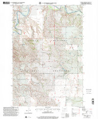
1997 Map of Spring Creek
USGS Topo · Published 2001About this map
The Little Missouri River meanders through the northwestern portion of this landscape, carving a valley across the expansive Little Missouri National Grassland. This 1990s-era revision shows a terrain defined by isolated livestock operations and scattered water sources in the high plains of Slope County. Isolated ranching outposts such as Johnson Ranch, Van Daele Ranch, and the Szymanski Ranch are linked by a network of unimproved trails and four-wheel-drive tracks, reflecting the sparse settlement pattern of western North Dakota. Hydrological features like Spring Creek and Spring Coulee provide essential drainage for the surrounding plateaus. Precise surveying lines are documented through the Sixteenth Guide Meridian West, which bisects the quadrangle between the Richland Center and Sunshine administrative districts, illustrating the continuing importance of the Public Land Survey System in managing these open lands.
Find a feature on this map
13 named features on this map. Tap any name to fly to it.
Don’t see what you’re looking for? This feature index may not catch every label — zoom into the map to look around manually.
Map Details
Editions of this 1997 Spring Creek Map
This is the sole edition of this map. No revisions or reprints were ever made.
Other maps of this area

1953 · Dickinson
USGS Topo · 1:250,000

1957 · Dickinson
USGS Topo · 1:250,000

1979 · Deep Creek North
USGS Topo · 1:24,000

1979 · Three V Crossing
USGS Topo · 1:24,000

1979 · Bullion Butte
USGS Topo · 1:24,000

1980 · Spring Creek
USGS Topo · 1:24,000

1980 · Boyce Creek West
USGS Topo · 1:24,000

1980 · Alpha
USGS Topo · 1:24,000

1980 · Belfield
USGS Topo · 1:100,000

1981 · Bowman
USGS Topo · 1:100,000