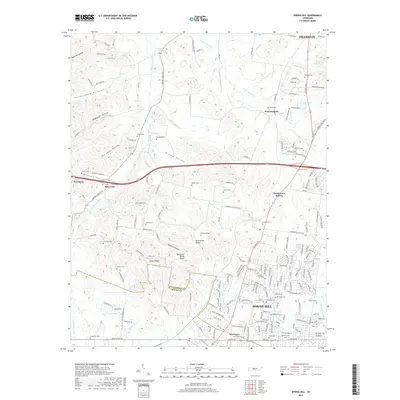
2019 Map of Spring Hill
USGS Topo · Published 2019About this map
Spring Hill and the surrounding Middle Tennessee landscape are captured in this 2019 survey, illustrating the convergence of historical rural topography and modern residential expansion. The terrain is defined by the Tennessee Valley Divide, with numerous hollows such as Doc Jones Hollow and Peckerwood Hollow cutting through the ridges. The regional history is preserved through an unusually high density of family cemeteries, including Harrison Cem, Patton Cem, and Lavender Cem, which dot the hillsides between Thompson's Station and Burwood. This network of burial sites serves as a spatial record of the area's early landowning families near the W Harpeth River. The map also traces the transition across the Williamson Co and Maury Co line, showing how established thoroughfares like Columbia Pike and the CSX railroad continue to shape the growth of New Town and its environs.
Find a feature on this map
198 named features on this map. Tap any name to fly to it.
Don’t see what you’re looking for? This feature index may not catch every label — zoom into the map to look around manually.
Map Details
Editions of this 2019 Spring Hill Map
This is the sole edition of this map. No revisions or reprints were ever made.
Other maps of this area

1901 · Colombia
USGS Topo · 1:125,000

1909 · Franklin
USGS Topo · 1:62,500

1936 · Godwin
USGS Topo · 1:24,000

1936 · Rally Hill
USGS Topo · 1:24,000

1936 · Spring Hill
USGS Topo · 1:24,000

1936 · Theta
USGS Topo · 1:24,000

1936 · Carters Creek
USGS Topo · 1:24,000

1936 · Bethesda
USGS Topo · 1:24,000

1940 · Godwin
USGS Topo · 1:24,000
1941 · Godwin
USGS Topo · 1:24,000