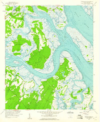
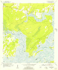
1958 Map of Spring Island
USGS Topo · Published 1961About this map
Spring Island and its neighboring sea islands are defined by an intricate network of tidal rivers and marshlands in this late 1950s survey. The landscape is marked by historical access points to the water, including Fripp Landing on Chechessee and Copp Landing on the Colleton River. This era shows the rural character of the South Carolina Lowcountry before modern development intensified, with community focal points centered at St Lukes Ch and Young Zion Ch. The geography reveals a series of substantial landmasses like Callawassie Island and Daws Island separated by the broad expanses of the Chechessee River and Broad River. Local genealogy is anchored by family-named landmarks such as Manigault Neck and Pinckney Neck, reflecting the long-standing settlement patterns of the region's coastal peninsulas.
Find a feature on this map
36 named features on this map. Tap any name to fly to it.
Don’t see what you’re looking for? This feature index may not catch every label — zoom into the map to look around manually.
Map Details
Editions of this 1958 Spring Island Map
4 editions found
Other maps of this area

1920 · Okatie
USGS Topo · 1:62,500

1920 · Hilton Head
USGS Topo · 1:62,500

1920 · Bluffton
USGS Topo · 1:62,500

1942 · Okatie
USGS Topo · 1:62,500

1944 · Fort Fremont
USGS Topo · 1:62,500

1945 · Bluffton
USGS Topo · 1:62,500

1945 · Hilton Head
USGS Topo · 1:62,500

1947 · Savannah
USGS Topo · 1:250,000

1948 · Savannah
USGS Topo · 1:250,000
1955 · Pritchardville
USGS Topo · 1:24,000