
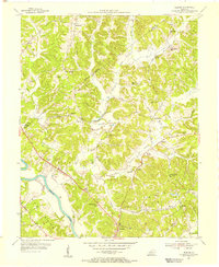
1954 Map of Spring Lick
USGS Topo · Published 1955About this map
Spring Lick and the surrounding rural landscape in mid-century Kentucky are defined by the winding corridor of the Illinois Central railroad. This transportation artery anchors several small communities, including Goffs (Steff P.O.) and the curiously named Do Stop. The terrain is characterized by high ridges like Peach Orchard Ridge and narrow valleys where local life centered around a dense network of country schools and churches. Genealogists will find a wealth of specific landmarks, from Free Zion Ch and Zion Harmony Ch to numerous community schools like Sipes Sch and Buck Creek Sch. The map also captures the intricate boundaries where Butler, Grayson, and Ohio counties meet, illustrating how these political divisions followed the natural contours of the hilly, creek-carved landscape.
Find a feature on this map
44 named features on this map. Tap any name to fly to it.
Don’t see what you’re looking for? This feature index may not catch every label — zoom into the map to look around manually.
Map Details
Editions of this 1954 Spring Lick Map
This is the sole edition of this map. No revisions or reprints were ever made.
Other maps of this area

1922 · Leitchfield
USGS Topo · 1:48,000

1925 · Spring Lick
USGS Topo · 1:62,500

1925 · Leitchfield
USGS Topo · 1:62,500

1932 · Fordsville
USGS Topo · 1:62,500

1953 · Mc Daniels
USGS Topo · 1:24,000

1953 · Ready
USGS Topo · 1:24,000

1953 · Falls Of Rough
USGS Topo · 1:24,000

1954 · Evansville
USGS Topo · 1:250,000

1954 · Welchs Creek
USGS Topo · 1:24,000
1954 · Flener
USGS Topo · 1:24,000