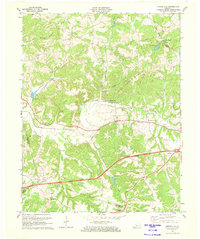
1971 Map of Spring Lick
USGS Topo · Published 1973About this map
The Illinois Central Railroad serves as a primary corridor through this section of Western Kentucky, passing through the community of Spring Lick and the curiously named Do Stop. The landscape is defined by the winding course of Caney Creek and its many tributaries, such as Richland Creek and Buck Creek. In the early 1970s, this area remained largely rural, characterized by the convergence of Grayson, Ohio, and Butler counties.
Find a feature on this map
39 named features on this map. Tap any name to fly to it.
Don’t see what you’re looking for? This feature index may not catch every label — zoom into the map to look around manually.
Map Details
Editions of this 1971 Spring Lick Map
This is the sole edition of this map. No revisions or reprints were ever made.
Other maps of this area

1922 · Leitchfield
USGS Topo · 1:48,000

1925 · Spring Lick
USGS Topo · 1:62,500

1925 · Leitchfield
USGS Topo · 1:62,500

1932 · Fordsville
USGS Topo · 1:62,500

1953 · Mc Daniels
USGS Topo · 1:24,000

1953 · Ready
USGS Topo · 1:24,000

1953 · Falls Of Rough
USGS Topo · 1:24,000

1954 · Evansville
USGS Topo · 1:250,000

1954 · Spring Lick
USGS Topo · 1:24,000

1954 · Welchs Creek
USGS Topo · 1:24,000