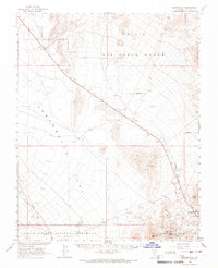
1966 Map of Springdale
USGS Topo · Published 1967About this map
Sarcobatus Flat dominates this mid-1960s survey of the Nevada desert, where the vast alkali plains meet the volcanic rises of the Bullfrog Hills and Oasis Mtn. The settlement of Springdale and the site of Ancram mark the edge of the Oasis Valley, while an Old Railroad Grade traces a line through the arid landscape toward the Pioneer site. This specific survey was conducted in cooperation with the Atomic Energy Commission, reflecting the era's focus on the surrounding high-security lands of the Nellis Air Force Range. Infrastructure of the Space Age is also evident at the NASA Tracking Sta located south of Ancram. The map further documents the northern fringes of Death Valley National Monument, capturing a period when industrial activity and government research intersected in this remote corner of Nye County.
Find a feature on this map
21 named features on this map. Tap any name to fly to it.
Don’t see what you’re looking for? This feature index may not catch every label — zoom into the map to look around manually.
Map Details
Editions of this 1966 Springdale Map
2 editions found
Other maps of this area

1908 · Kawich
USGS Topo · 1:250,000

1908 · Lida
USGS Topo · 1:250,000

1908 · Furnace Creek
USGS Topo · 1:250,000

1908 · Ballarat
USGS Topo · 1:250,000

1910 · Furnace Creek
USGS Topo · 1:250,000

1913 · Lida
USGS Topo · 1:250,000

1913 · Ballarat
USGS Topo · 1:250,000

1942 · Tolicha Peak
USGS Topo · 1:125,000

1942 · Bullfrog
USGS Topo · 1:125,000

1948 · Death Valley
USGS Topo · 1:250,000