1958 Map of Springfield North
USGS Topo · Published 1961About this map
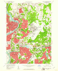
The industrial and military landscape of the mid-Massachusetts river valley is anchored by the Connecticut River and the massive Westover Air Force Base. In this late 1950s survey, the expansion of Chicopee and Holyoke is evident, with residential neighborhoods like Fairview and Aldenville flanking the strategic Massachusetts Turnpike. The river remains a central artery of industry, evidenced by the Holyoke Dam and the network of canals in the city center.
Find a feature on this map
117 named features on this map. Tap any name to fly to it.
Don’t see what you’re looking for? This feature index may not catch every label — zoom into the map to look around manually.
Map Details
Editions of this 1958 Springfield North Map
2 editions found

Other maps of this area

1885 · Northampton
USGS Topo · 1:62,500

1886 · Springfield
USGS Topo · 1:62,500

1886 · Northampton
USGS Topo · 1:62,500

1887 · Palmer
USGS Topo · 1:62,500

1887 · Belchertown
USGS Topo · 1:62,500

1889 · Springfield
USGS Topo · 1:62,500

1889 · Palmer
USGS Topo · 1:62,500

1890 · Belchertown
USGS Topo · 1:62,500

1891 · Northampton
USGS Topo · 1:62,500

1893 · Northampton
USGS Topo · 1:62,500