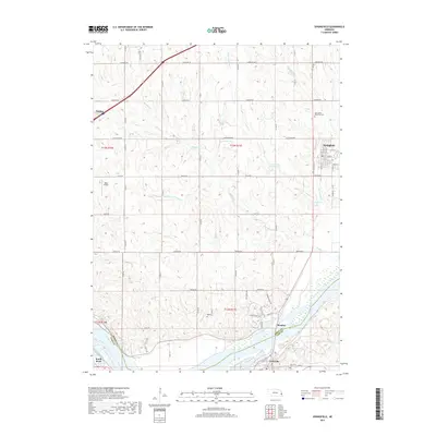
2017 Map of Springfield
USGS Topo · Published 2017About this map
The Platte River corridor defines the southern boundary of this Sarpy County landscape, where the settlements of Meadow, Louisville, and South Bend anchor the riverfront. Moving north from the river valley, the terrain transitions into a systematic grid of section roads and rolling drainages including Buffalo Cr and Turtle Cr. The town of Springfield serves as a primary local hub, shown with its residential street grid including Main St and Elm St. Genealogy and local history researchers will find several well-defined burial grounds across the quadrangle, notably the Springfield Memorial Cem and Bali Cem near the central townships. The northwestern corner reaches toward Gretna, illustrating the modern expansion of these communities near the Interstate 80 corridor, while the presence of the Koke Airport and Turtle Creek Reservoir 2 points to twentieth-century infrastructure development within this traditional agricultural region.
Find a feature on this map
37 named features on this map. Tap any name to fly to it.
Don’t see what you’re looking for? This feature index may not catch every label — zoom into the map to look around manually.
Map Details
Editions of this 2017 Springfield Map
This is the sole edition of this map. No revisions or reprints were ever made.
Other maps of this area

1893 · Fremont
USGS Topo · 1:125,000

1896 · Fremont
USGS Topo · 1:125,000

1903 · Weeping Water
USGS Topo · 1:125,000

1929 · Weeping Water
USGS Topo · 1:125,000

1955 · Fremont
USGS Topo · 1:250,000

1955 · Lincoln
USGS Topo · 1:250,000

1956 · Gretna
USGS Topo · 1:24,000

1956 · Cedar Creek
USGS Topo · 1:24,000

1956 · Ralston
USGS Topo · 1:24,000

1956 · Springfield
USGS Topo · 1:24,000