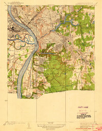
1938 Map of Springfield South
USGS Topo · Published 1938About this map
The Connecticut River dominates the western half of this industrial-era landscape, its waters bridged by the North End Bridge, Memorial Bridge, and South End Bridge. This 1930s survey reveals a densely developed Springfield characterized by critical infrastructure like the US Armory and the sprawling rail yards near Union Sta. The industrial footprint of the Boston and Albany RR and the New York New Haven and Hartford RR highlights the city's role as a primary New England transit hub. To the south and east, the map captures the residential and recreational expansion into Longmeadow and East Longmeadow, featuring the Franconia Golf Course and Springfield College. The presence of institutions such as Springfield Hospital and Mercy Hospital indicates a mature urban center during the interwar period.
Find a feature on this map
53 named features on this map. Tap any name to fly to it.
Don’t see what you’re looking for? This feature index may not catch every label — zoom into the map to look around manually.
Map Details
Editions of this 1938 Springfield South Map
3 editions found
Other maps of this area

1886 · Springfield
USGS Topo · 1:62,500

1887 · Palmer
USGS Topo · 1:62,500

1889 · Springfield
USGS Topo · 1:62,500

1889 · Palmer
USGS Topo · 1:62,500

1892 · Hartford
USGS Topo · 1:62,500

1892 · Tolland
USGS Topo · 1:62,500

1893 · Springfield
USGS Topo · 1:62,500

1893 · Palmer
USGS Topo · 1:62,500

1895 · Springfield
USGS Topo · 1:62,500

1896 · Holyoke
USGS Topo · 1:125,000