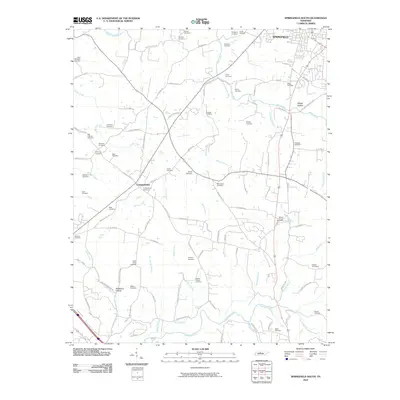
2010 Map of Springfield South
USGS Topo · Published 2010About this map
Springfield marks the northern edge of this landscape, where the town's expansion meets a countryside defined by deep-rooted family legacy and small-scale agriculture. The terrain is intricately drained by Sycamore Creek and the Sulphur Fork Red River, creating a network of ridges and hollows that historically dictated settlement patterns. The map reveals an exceptional density of family and community burial grounds, such as Saint Michaels Cemetery, Palestine Cemetery, and the Martins Chapel Cemetery, indicating a long-established population that remained closely tied to their land well into the 21st century. While Coopertown serves as a central hub, smaller locales like Mcmahon Hollow and Sleepy Hollow showcase the traditional naming conventions of Middle Tennessee's topography. This record of the area's rural road network provides a precise view of how modern developments have integrated with older, family-named landmarks.
Find a feature on this map
99 named features on this map. Tap any name to fly to it.
Don’t see what you’re looking for? This feature index may not catch every label — zoom into the map to look around manually.
Map Details
Editions of this 2010 Springfield South Map
This is the sole edition of this map. No revisions or reprints were ever made.
Other maps of this area

1903 · Nashville
USGS Topo · 1:125,000

1931 · Ridgetop
USGS Topo · 1:62,500

1935 · Ridgetop
USGS Topo · 1:62,500

1952 · Springfield North
USGS Topo · 1:24,000

1952 · Youngville
USGS Topo · 1:24,000

1955 · Whites Creek
USGS Topo · 1:24,000

1955 · Forest Grove
USGS Topo · 1:24,000

1956 · Nashville
USGS Topo · 1:250,000

1957 · Adams
USGS Topo · 1:24,000

1957 · Pleasant View
USGS Topo · 1:24,000