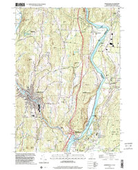
1998 Map of Springfield
USGS Topo · Published 2002About this map
The Connecticut River serves as the primary boundary between Vermont and New Hampshire in this late-1990s survey, anchoring a landscape where industrial history meets protected woodlands. In Springfield, the Black River winds through the urban center near Hartness Park, passing sites like Goulds Mill and the local sewage infrastructure that supported the town's development. The map reveals a dense network of civic life, from the Union St Sch and High Sch to several outlying cemeteries including Eureka Cem and Crown Point Cem.
Find a feature on this map
61 named features on this map. Tap any name to fly to it.
Don’t see what you’re looking for? This feature index may not catch every label — zoom into the map to look around manually.
Map Details
Editions of this 1998 Springfield Map
This is the sole edition of this map. No revisions or reprints were ever made.
Other maps of this area

1926 · Claremont
USGS Topo · 1:62,500

1927 · Bellows Falls
USGS Topo · 1:48,000

1928 · Ludlow
USGS Topo · 1:48,000

1929 · Claremont
USGS Topo · 1:62,500

1929 · Ludlow
USGS Topo · 1:62,500

1930 · Saxtons River
USGS Topo · 1:48,000

1930 · Bellows Falls
USGS Topo · 1:62,500

1932 · Ludlow
USGS Topo · 1:62,500

1933 · Saxtons River
USGS Topo · 1:62,500

1950 · Glens Falls
USGS Topo · 1:250,000