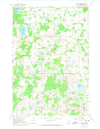
1961 Map of Springvale
USGS Topo · Published 1974About this map
The town of Springvale serves as the focal point for this early 1960s survey of Isanti and Kanabec counties, where the landscape is defined by a dense concentration of rural community institutions. The map reveals a remarkably organized social geography, featuring a series of landmark churches including North Maple Ridge Ch, Maple Ridge Ch, and South Maple Ridge Ch. These religious centers are complemented by a network of local education sites such as Hiawatha Sch, Franklin Sch, and Coin Sch, alongside the Grange Hall and Townhall, illustrating the tight-knit settlement patterns of central Minnesota. Scattered water bodies like Lory Lake, Lewis Lake, and Grass Lake provide natural breaks in the terrain, while early industrial activity is marked by Gravel Pits in the northwest. The presence of the Stanchfield and Maple Ridge boundaries further delineates the administrative and community identity of this agricultural region.
Find a feature on this map
37 named features on this map. Tap any name to fly to it.
Don’t see what you’re looking for? This feature index may not catch every label — zoom into the map to look around manually.
Map Details
Editions of this 1961 Springvale Map
2 editions found
Other maps of this area

1953 · Stillwater
USGS Topo · 1:250,000

1955 · Stillwater
USGS Topo · 1:250,000

1958 · Stillwater
USGS Topo · 1:250,000

1961 · Bradford
USGS Topo · 1:24,000

1961 · Cambridge
USGS Topo · 1:62,500

1961 · Brook Park
USGS Topo · 1:62,500

1961 · Springvale
USGS Topo · 1:24,000

1961 · Dalbo
USGS Topo · 1:24,000

1961 · Wyanett
USGS Topo · 1:24,000

1961 · Dalbo
USGS Topo · 1:62,500