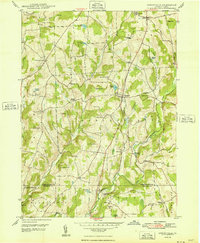
1948 Map of Springville
USGS Topo · Published 1948About this map
Springville serves as the central hub of this Susquehanna County landscape, where the rural economy of the late 1940s is defined by a dense network of family-named hills and hollows. The terrain is marked by steep ridges such as Strickland Hill and Jennings Hill, which hem in the drainage of Meshoppen Creek and its many tributaries. This survey reveals a community structure rooted in small crossroads like Auburn Four Corners, Kasson Corners, and Schlessers Corners, many of which developed around local water sources and schoolhouses like the Wallace Hill Sch.
Find a feature on this map
60 named features on this map. Tap any name to fly to it.
Don’t see what you’re looking for? This feature index may not catch every label — zoom into the map to look around manually.
Map Details
Editions of this 1948 Springville Map
2 editions found
Other maps of this area

1943 · Montrose
USGS Topo · 1:62,500

1943 · Le Raysville
USGS Topo · 1:62,500

1945 · Montrose
USGS Topo · 1:62,500

1945 · Le Raysville
USGS Topo · 1:62,500

1945 · Meshoppen
USGS Topo · 1:62,500

1945 · Auburn Center
USGS Topo · 1:24,000

1945 · Meshoppen
USGS Topo · 1:24,000

1946 · Tunkhannock
USGS Topo · 1:62,500

1946 · Factoryville
USGS Topo · 1:24,000

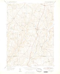
1946 · Springville
USGS Topo · 1:24,000