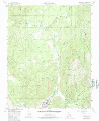
1977 Map of Springville
USGS Topo · Published 1987About this map
Springville sits at the confluence of mountain waters and valley life, shown here in a 1977 update of 1950s field data. The settlement of Springville serves as the focal point, featuring a Soda Spring, a local Race Track, and the Middle Fork Tule River. The landscape is defined by the sharp transition from the residential clusters near Pleasant Valley to the steep, protected slopes of the Sequoia National Forest. Notable peaks like Hatchet Peak and Lumreau Mtn. loom over the river forks, while infrastructure like a Landing Strip and a Powerhouse north of town indicate the area's development for utility and light aviation.
Find a feature on this map
35 named features on this map. Tap any name to fly to it.
Don’t see what you’re looking for? This feature index may not catch every label — zoom into the map to look around manually.
Map Details
Editions of this 1977 Springville Map
This is the sole edition of this map. No revisions or reprints were ever made.
Other maps of this area

1904 · Kaweah
USGS Topo · 1:125,000

1909 · Kaweah
USGS Topo · 1:125,000

1937 · Kaweah
USGS Topo · 1:125,000

1948 · Fresno
USGS Topo · 1:250,000

1955 · Fresno
USGS Topo · 1:250,000

1956 · Fresno
USGS Topo · 1:250,000

1956 · Globe
USGS Topo · 1:24,000
1956 · Success
USGS Topo · 1:24,000
1956 · Mineral King
USGS Topo · 1:62,500
1956 · Camp Nelson
USGS Topo · 1:62,500