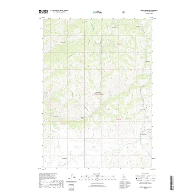
2020 Map of Sprout Mountain
USGS Topo · Published 2020About this map
Moores Flat sits at the southern edge of this high-elevation terrain, marking one of the few named level clearings amidst the deep drainages of the Sawtooth National Forest. The landscape is defined by a dense network of gulches and creeks that flow toward the larger Lime Cr and Moores Cr systems. Dominant ridges such as Deer Creek Ridge and Slickear Ridge separate these steep-walled canyons, while Sprout Mtn anchors the northern high ground. Traceable routes like the Presidents Trail wind through the northeast, reflecting the area's modern usage for forest access. The map reveals the intricate water system of the Elmore County back-country, including numerous tributaries like Honey Cr and Whitney Cr, alongside historical geographic markers such as Sawmill Gulch and Beaverdam Gulch that hint at the region's past resource and wildlife activity.
Find a feature on this map
46 named features on this map. Tap any name to fly to it.
Don’t see what you’re looking for? This feature index may not catch every label — zoom into the map to look around manually.
Map Details
Editions of this 2020 Sprout Mountain Map
This is the sole edition of this map. No revisions or reprints were ever made.
Other maps of this area

1892 · Camas Prairie
USGS Topo · 1:125,000

1893 · Camas Prairie
USGS Topo · 1:125,000

1894 · Rocky Bar
USGS Topo · 1:125,000

1955 · Hailey
USGS Topo · 1:250,000

1959 · Hailey
USGS Topo · 1:250,000

1962 · Hailey
USGS Topo · 1:250,000

1963 · High Prairie
USGS Topo · 1:24,000

1963 · Deer Mountain
USGS Topo · 1:24,000
1963 · Sprout Mtn
USGS Topo · 1:24,000

1963 · Hill City
USGS Topo · 1:24,000