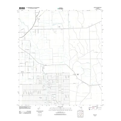
2012 Map of Spuds
USGS Topo · Published 2012About this map
Agricultural patterns and local transit corridors define this Saint Johns County landscape, where the settlements of Spuds and Byrd are positioned along the primary rail and road routes. The topography is dominated by the meandering path of Deep Cr, which drains the surrounding plains. The presence of Hutson Airfield suggests the importance of local aviation in this rural pocket of Florida, while the name Spuds reflects the region's historic identity in potato farming. Near Gopher Ridge, a grid of residential streets indicates more recent community development, contrasting with the expansive open tracts that characterize the northern portion of the survey. Significant local thoroughfares like Cowpen Branch Rd link these small centers, illustrating the infrastructure supporting both the farming economy and local connectivity in the early 21st century.
Find a feature on this map
6 named features on this map. Tap any name to fly to it.
Don’t see what you’re looking for? This feature index may not catch every label — zoom into the map to look around manually.
Map Details
Editions of this 2012 Spuds Map
This is the sole edition of this map. No revisions or reprints were ever made.
Other maps of this area

1912 · Palatka
USGS Topo · 1:48,000

1915 · Palatka
USGS Topo · 1:62,500

1937 · Elkton
USGS Topo · 1:24,000

1937 · Crescent Beach
USGS Topo · 1:24,000

1937 · Dinner Island
USGS Topo · 1:48,000

1943 · St. Augustine
USGS Topo · 1:62,500

1943 · Dinner Island
USGS Topo · 1:62,500

1944 · Dinner Island
USGS Topo · 1:62,500

1947 · Bostwick
USGS Topo · 1:50,000
1949 · Riverdale
USGS Topo · 1:24,000