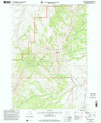
1997 Map of Spur Mountain
USGS Topo · Published 2002About this map
Beaverhead National Forest defines this high-elevation landscape in the late 1990s, where the dramatic peaks of the Snowcrest Range separate the headwaters of the Ruby River from the northern drainages. The map reveals a complex hydrologic network, including Ledford Creek and the Big South Fork Ruby River, channeled through steep terrain marked by Spur Mountain and Sliderock Mountain. The absence of developed roads highlights the primitive character of the region during this era, with transit limited to routes like the Snowcrest Trail and the Gilbert Trail. Genealogists and historians can trace traditional passage points through the mountains at Ledford Pass and the distinctive geological break known as The Notch. This survey records a wild portion of Madison County where land use was primarily defined by the Second Standard Parallel South and the natural boundaries of the Centennial Divide.
Find a feature on this map
40 named features on this map. Tap any name to fly to it.
Don’t see what you’re looking for? This feature index may not catch every label — zoom into the map to look around manually.
Map Details
Editions of this 1997 Spur Mountain Map
This is the sole edition of this map. No revisions or reprints were ever made.
Other maps of this area

1888 · Three Forks
USGS Topo · 1:250,000

1893 · Dillon
USGS Topo · 1:250,000

1894 · Three Forks
USGS Topo · 1:250,000

1895 · Three Forks
USGS Topo · 1:250,000

1947 · Bozeman
USGS Topo · 1:250,000

1948 · Bozeman
USGS Topo · 1:250,000

1949 · Varney
USGS Topo · 1:62,500

1950 · Monument Ridge
USGS Topo · 1:62,500

1955 · Bozeman
USGS Topo · 1:250,000

1955 · Dubois
USGS Topo · 1:250,000