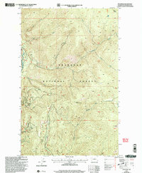
2001 Map of Spur Peak
USGS Topo · Published 2004About this map
The Okanogan National Forest dominates this high-elevation landscape in north-central Washington, shaped by the drainage patterns of the Chewuch River and its numerous tributaries. High summits such as South Twentymile Peak and Spur Peak anchor the topography, which is defined by a dense network of drainages including Twentymile Creek, Boulder Creek, and Snake Creek. Human presence is marked primarily by the Twentymile Trail and a series of forest roads navigating the steep grades. This era of forest management is reflected in the systematic division of the land into protraction blocks like pb43 and pb37, highlighting the transition from traditional section-and-township grids to more specialized forestry mapping units. The map details the intricate hydrography of the Cascades, tracing the paths of North Fork Twentymile Creek, Claw Creek, and Timber Creek as they descend toward the main river valley.
Find a feature on this map
27 named features on this map. Tap any name to fly to it.
Don’t see what you’re looking for? This feature index may not catch every label — zoom into the map to look around manually.
Map Details
Editions of this 2001 Spur Peak Map
This is the sole edition of this map. No revisions or reprints were ever made.
Other maps of this area

1906 · Chopaka
USGS Topo · 1:125,000

1954 · Okanogan
USGS Topo · 1:250,000

1955 · Concrete
USGS Topo · 1:250,000

1956 · Tiffany Mountain
USGS Topo · 1:62,500

1956 · Horseshoe Basin
USGS Topo · 1:62,500

1958 · Concrete
USGS Topo · 1:250,000

1958 · Okanogan
USGS Topo · 1:250,000

1962 · Concrete
USGS Topo · 1:250,000

1963 · Doe Mountain
USGS Topo · 1:62,500

1969 · Mt. Barney
USGS Topo · 1:24,000