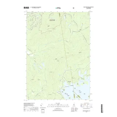
2018 Map of Squam Mountains
USGS Topo · Published 2018About this map
The shorelines of Squam Lake define the settled landscape in this 2018 survey of Carroll County. Notable lakeside clusters include Rockywold and Deephaven, which represent the enduring character of New Hampshire's historic seasonal retreats. These settlements are positioned near the protected expanse of the White Mountain National Forest, where the terrain shifts toward more remote peaks and valleys. The Mad River flows through the upper reaches of the map, carving a path through the wooded highlands that surround the basin. The proximity of these lakeside communities to the national forest boundary suggests a long-standing balance between recreational development and wilderness preservation in the Squam Mountains region.
Find a feature on this map
3 named features on this map. Tap any name to fly to it.
Don’t see what you’re looking for? This feature index may not catch every label — zoom into the map to look around manually.
Map Details
Editions of this 2018 Squam Mountains Map
This is the sole edition of this map. No revisions or reprints were ever made.
Other maps of this area

1909 · Winnepesaukee
USGS Topo · 1:62,500

1925 · Holderness
USGS Topo · 1:62,500

1927 · Holderness
USGS Topo · 1:62,500

1928 · Plymouth
USGS Topo · 1:62,500

1931 · Plymouth
USGS Topo · 1:62,500

1931 · Mt. Chocorua
USGS Topo · 1:62,500

1949 · Portland
USGS Topo · 1:250,000

1956 · Winnipesaukee
USGS Topo · 1:62,500

1956 · Holderness
USGS Topo · 1:62,500

1956 · Portland
USGS Topo · 1:250,000