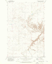
1972 Map of Square Butte NE
USGS Topo · Published 1976About this map
Flat Creek winds through the northern portion of this Montana landscape, cutting across the broad terrain simply labeled Flat. The area is characterized by the stark transition from high tablelands into the deeply eroded drainage of Cut Bank Coulee, which dominates the southeastern quadrant. This 1972 field-checked survey reveals a sparse, functional infrastructure focused on resource extraction and remote access, featuring a localized Gravel Pit and several Well sites. The presence of a dedicated Landing Strip in the southern section underscores the vast distances of Chouteau County, where aviation served as a vital link for agricultural or industrial operations far from established town centers.
Find a feature on this map
6 named features on this map. Tap any name to fly to it.
Don’t see what you’re looking for? This feature index may not catch every label — zoom into the map to look around manually.
Map Details
Editions of this 1972 Square Butte NE Map
This is the sole edition of this map. No revisions or reprints were ever made.
Other maps of this area

1890 · Fort Benton
USGS Topo · 1:250,000

1892 · Fort Benton
USGS Topo · 1:250,000

1897 · Fort Benton
USGS Topo · 1:250,000

1953 · Eagle Buttes
USGS Topo · 1:24,000

1953 · Last Chance Bench
USGS Topo · 1:24,000

1954 · Great Falls
USGS Topo · 1:250,000

1954 · Dark Butte
USGS Topo · 1:24,000

1954 · Lewistown
USGS Topo · 1:250,000

1957 · Great Falls
USGS Topo · 1:250,000

1959 · Lewistown
USGS Topo · 1:250,000