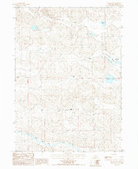
1987 Map of Square Lake
USGS Topo · Published 1987About this map
The North Loup River winds through the southern edge of this Sandhills landscape, providing a critical water source in an otherwise arid expanse of undulating dunes. Ranching life is documented through established operations like Sears Ranch and Kidder Ranch, which are situated near the seasonal drainages of Big Dry Valley and Wamaduze Valley. The area is defined by its numerous isolated basins and wetlands, ranging from the prominent Square Lake and Stout Lake to smaller features like Alkali Pond and Mud Lake. These features reveal the intricate hydrology of the region in the late 1980s, where wind-formed depressions in the sand created a network of semi-permanent lakes and meadows essential for cattle grazing. The proximity of Twin Lakes and Packingham Lake further illustrates the varied water table that supported localized settlement and agricultural viability in this section of Cherry County.
Find a feature on this map
16 named features on this map. Tap any name to fly to it.
Don’t see what you’re looking for? This feature index may not catch every label — zoom into the map to look around manually.
Map Details
Editions of this 1987 Square Lake Map
This is the sole edition of this map. No revisions or reprints were ever made.
Other maps of this area

1949 · Big Falls
USGS Topo · 1:62,500

1950 · Powderhorn Valley
USGS Topo · 1:62,500

1950 · Kennedy
USGS Topo · 1:62,500

1951 · Big Falls
USGS Topo · 1:62,500

1951 · Bull Lake
USGS Topo · 1:62,500

1957 · Valentine
USGS Topo · 1:250,000

1959 · Valentine
USGS Topo · 1:250,000

1985 · Mullen
USGS Topo · 1:100,000

1985 · Goose Creek
USGS Topo · 1:100,000

1985 · Cody
USGS Topo · 1:100,000