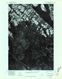
1975 Map of Square Lake NE
USGS Topo · Published 1981About this map
The settlement of St Agatha stands out along the northwestern shores of Long Lake in this mid-1970s orthophotoquad of Aroostook County. This unique aerial perspective reveals the distinct strip-farming patterns characteristic of the Acadian heritage in northern Maine, where long, narrow lots extend back from the water and road networks. The landscape transition is stark between the cleared agricultural lands near the lake and the dense interior timberlands. Moving south, the map follows the interconnected water system through Sinclair and the narrowing of the water at Mud Lake, eventually reaching the northern tip of Cross Lake near Guerette. This document serves as a clear record of land use and forest density during a period of established lakeside settlement and rural development.
Find a feature on this map
6 named features on this map. Tap any name to fly to it.
Don’t see what you’re looking for? This feature index may not catch every label — zoom into the map to look around manually.
Map Details
Editions of this 1975 Square Lake NE Map
This is the sole edition of this map. No revisions or reprints were ever made.
Other maps of this area

1927 · Stockholm
USGS Topo · 1:48,000

1927 · Square Lake
USGS Topo · 1:48,000

1931 · Square Lake
USGS Topo · 1:62,500

1931 · Stockholm
USGS Topo · 1:62,500

1932 · Frenchville
USGS Topo · 1:48,000

1935 · Frenchville
USGS Topo · 1:62,500

1938 · Grand Isle
USGS Topo · 1:62,500

1940 · Grand Isle
USGS Topo · 1:62,500

1953 · Stockholm
USGS Topo · 1:62,500

1953 · Square Lake
USGS Topo · 1:62,500
Featured Places
- Madawaska, ME
- Saint Agatha, ME
- Cross Lake Township, ME
- Sinclair Township, ME
- Guerette, Cross Lake Township