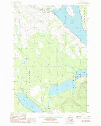
1986 Map of St. Agatha
USGS Topo · Published 1986About this map
Long Lake and Cross Lake dominate this northern Maine landscape, where water and woodlands define the settlement patterns of the 1980s. The community of St Agatha is situated along the northern shore of Long Lake, connected to the southern village of Guerette and the lakeside hamlet of Sinclair. This region, documented during a mid-1980s field check, shows the importance of the lakefront for both industry and residential life, featuring a Post Office and a Cemetery near the water's edge.
Find a feature on this map
21 named features on this map. Tap any name to fly to it.
Don’t see what you’re looking for? This feature index may not catch every label — zoom into the map to look around manually.
Map Details
Editions of this 1986 St. Agatha Map
This is the sole edition of this map. No revisions or reprints were ever made.
Other maps of this area

1927 · Stockholm
USGS Topo · 1:48,000

1927 · Square Lake
USGS Topo · 1:48,000

1931 · Square Lake
USGS Topo · 1:62,500

1931 · Stockholm
USGS Topo · 1:62,500

1932 · Frenchville
USGS Topo · 1:48,000

1935 · Frenchville
USGS Topo · 1:62,500

1938 · Grand Isle
USGS Topo · 1:62,500

1940 · Grand Isle
USGS Topo · 1:62,500

1953 · Stockholm
USGS Topo · 1:62,500

1953 · Square Lake
USGS Topo · 1:62,500
Featured Places
- Madawaska, ME
- Saint Agatha, ME
- Cross Lake Township, ME
- Sinclair Township, ME
- Guerette, Cross Lake Township