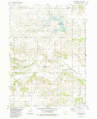
1983 Map of St. Charles NW
USGS Topo · Published 1983About this map
The McBride Covered Bridge stands as a central landmark over the North Branch of the North River in this early 1980s portrait of Madison County. The landscape is defined by the rolling drainage basins of Badger Creek, Elm Creek, and Cedar Creek, which converge across the boundaries of Jefferson, Lee, Crawford, and Union townships. Local heritage is deeply rooted in the rural road network and numerous small burial grounds, including Jefferson Cem, North McDonald Cem, and the United Brethren Cem. The northern section of the map is dominated by the Badger Creek State Recreation Area, showing the area's transition toward public conservation and leisure. Genealogists can trace the proximity of these community landmarks to the winding river system and Trinity Ch, offering a spatial record of the county’s agricultural and social foundations.
Find a feature on this map
17 named features on this map. Tap any name to fly to it.
Don’t see what you’re looking for? This feature index may not catch every label — zoom into the map to look around manually.
Map Details
Editions of this 1983 St. Charles NW Map
This is the sole edition of this map. No revisions or reprints were ever made.
Other maps of this area

1908 · Waukee
USGS Topo · 1:62,500

1949 · Adel
USGS Topo · 1:62,500

1951 · Adel
USGS Topo · 1:62,500

1951 · St. Charles
USGS Topo · 1:62,500

1952 · Winterset
USGS Topo · 1:62,500

1954 · Omaha
USGS Topo · 1:250,000

1954 · Des Moines
USGS Topo · 1:250,000

1956 · Des Moines
USGS Topo · 1:250,000

1957 · Des Moines
USGS Topo · 1:250,000

1957 · Omaha
USGS Topo · 1:250,000