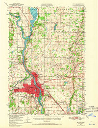
1950 Map of St. Cloud
USGS Topo · Published 1966About this map
The Mississippi River anchors this 1950 survey, serving as the industrial and topographic spine for St Cloud and its neighboring river towns. The urban core shows a high density of institutional landmarks, including the State Teachers College, Technical High Sch, and the sprawling State Reformatory on the southeast side. Across the water, Sauk Rapids and Sartell mark the continued expansion of the paper and milling corridor. The surrounding townships like Minden and Haven are characterized by a dense network of numbered country schools and small parish churches such as St Patricks Ch. To the north, the terrain transitions into the wetlands and shores of Little Rock Lake, while the western edge is defined by the granite extraction sites near Waite Park, where several quarries and gravel pits are noted.
Find a feature on this map
81 named features on this map. Tap any name to fly to it.
Don’t see what you’re looking for? This feature index may not catch every label — zoom into the map to look around manually.
Map Details
Editions of this 1950 St. Cloud Map
3 editions found
Other maps of this area

1948 · Pierz
USGS Topo · 1:62,500

1948 · Little Falls
USGS Topo · 1:62,500

1950 · Little Falls
USGS Topo · 1:62,500

1950 · Pierz
USGS Topo · 1:62,500

1950 · St. Cloud
USGS Topo · 1:62,500

1951 · Annandale
USGS Topo · 1:62,500

1953 · Saint Cloud
USGS Topo · 1:250,000

1953 · Stillwater
USGS Topo · 1:250,000

1955 · Stillwater
USGS Topo · 1:250,000

1957 · Saint Cloud
USGS Topo · 1:250,000