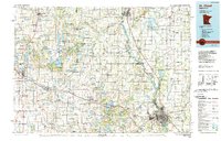
1986 Map of St. Cloud
USGS Topo · Published 1990About this map
St Cloud and its industrial corridor along the Mississippi River serve as the focal point of this mid-1980s landscape, where the urban expansion of Waite Park and Sauk Rapids meets the agricultural heartland of central Minnesota. The region's development is closely tied to its transportation network, featuring the primary lines of the Burlington Northern and Soo Line railroads, alongside major routes like Interstate 94.
Find a feature on this map
146 named features on this map. Tap any name to fly to it.
Don’t see what you’re looking for? This feature index may not catch every label — zoom into the map to look around manually.
Map Details
Editions of this 1986 St. Cloud Map
2 editions found
Other maps of this area

1947 · Flensburg
USGS Topo · 1:25,000

1948 · Belle Prairie
USGS Topo · 1:62,500

1948 · Pierz
USGS Topo · 1:62,500

1948 · Lastrup
USGS Topo · 1:62,500

1948 · Cushing
USGS Topo · 1:62,500

1948 · Little Falls
USGS Topo · 1:62,500

1950 · Lastrup
USGS Topo · 1:62,500

1950 · Swanville
USGS Topo · 1:62,500

1950 · Belle Prairie
USGS Topo · 1:62,500

1950 · Little Falls
USGS Topo · 1:62,500