Loading...
Loading map...1958 Map of St. David
USGS Topo · Published 1981About this map
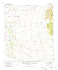
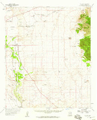
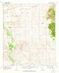
Contention (Ruins) and the Quiburi Mission (Ruins) stand as quiet markers of earlier occupation along the San Pedro River in this mid-century portrait of Cochise County. The valley floor is defined by a network of water management, from the St David Ditch to scattered Artesian Wells, supporting the agricultural life centered around St David and smaller stops like Curtiss and Land. To the west, the Lonesome Valley stretches toward the mountains, while the eastern horizon is dominated by the Dragoon Mountains within the Coronado National Forest.
Find a feature on this map
41 named features on this map. Tap any name to fly to it.
Don’t see what you’re looking for? This feature index may not catch every label — zoom into the map to look around manually.
Map Details
Date Portrayed1958
Date Published1981
PublisherU.S. Geological Survey
Map TypeTopographic
Scale1:62,500
Physical Dimensions18 x 21.9 inches
Editions of this 1958 St. David Map
3 editions found
Historical Maps of Boquillas Through Time

Featured Locations
Source Details
SourceU.S. Geological Survey
CopyrightPublic Domain