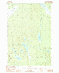
1989 Map of St. John Ponds
USGS Topo · Published 1989About this map
The Baker Branch St John River and its associated chain of ponds anchor this Somerset County landscape during the late 1980s. The area is defined by a dense network of water bodies including Fifth St John Pond, Fourth St John Pond, and Third St John Pond, which are linked by Baker Stream. This topographic study reveals a rugged interior where industry is represented by scattered Gravel Pits amidst the timberlands. Elevations rise sharply at Summit Mountain and Nuthedus Mountain, while the northern portion of the map is shaped by the North Branch Penobscot River. The presence of numerous brooks such as Sheehan Brook and Austin Brook illustrates the complex drainage patterns characteristic of the Maine North Woods before the turn of the millennium.
Find a feature on this map
34 named features on this map. Tap any name to fly to it.
Don’t see what you’re looking for? This feature index may not catch every label — zoom into the map to look around manually.
Map Details
Editions of this 1989 St. John Ponds Map
This is the sole edition of this map. No revisions or reprints were ever made.
Other maps of this area

1949 · Jackman
USGS Topo · 1:250,000

1954 · Seboomook Lake
USGS Topo · 1:62,500

1954 · St. John Pond
USGS Topo · 1:62,500

1954 · Presque Isle
USGS Topo · 1:250,000

1954 · Millinocket
USGS Topo · 1:250,000

1956 · Penobscot Lake
USGS Topo · 1:62,500

1957 · Norris Brook
USGS Topo · 1:62,500

1958 · Presque Isle
USGS Topo · 1:250,000

1958 · Millinocket
USGS Topo · 1:250,000

1958 · Saint John Pond
USGS Topo · 1:62,500