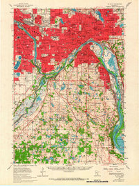
1951 Map of St. Paul
USGS Topo · Published 1966About this map
The Mississippi River carves a deep path through the Twin Cities in this early 1950s depiction, anchoring a landscape where institutional campuses and transit hubs define the urban core. To the west, the University of Minnesota and Augsburg College sit near the river's bend, while the vast grounds of the Fort Snelling Reservation and the adjacent Fort Snelling National Cem occupy the strategic confluence with the Minnesota River. This era shows the massive footprint of Wold Chamberlain Airport during a period of significant regional growth.
Find a feature on this map
189 named features on this map. Tap any name to fly to it.
Don’t see what you’re looking for? This feature index may not catch every label — zoom into the map to look around manually.
Map Details
Editions of this 1951 St. Paul Map
2 editions found

Other maps of this area

1896 · Minneapolis
USGS Topo · 1:62,500

1896 · St. Paul
USGS Topo · 1:62,500

1901 · Minneapolis
USGS Topo · 1:62,500

1902 · White Bear
USGS Topo · 1:62,500

1902 · Anoka
USGS Topo · 1:62,500

1946 · Hudson
USGS Topo · 1:62,500

1948 · Stillwater
USGS Topo · 1:62,500

1949 · Hudson
USGS Topo · 1:62,500

1949 · Stillwater
USGS Topo · 1:62,500

1949 · Lake Elmo
USGS Topo · 1:24,000