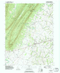
1990 Map of St Thomas
USGS Topo · Published 1995About this map
The ridge-and-valley landscape of Franklin County is defined here by the steep slopes of Kittatinny Mountain and Broad Mountain, separated by the distinct corridor of Horse Valley. At the foot of these ranges, the settlement of St. Thomas serves as a local hub, surrounded by smaller communities such as Edenville and the site of Franklin Furnace. The map illustrates a late 20th-century mix of forest conservation and military utility, with the boundaries of the Letterkenny Army Depot and Buchanan State Forest meeting agricultural lands.
Find a feature on this map
52 named features on this map. Tap any name to fly to it.
Don’t see what you’re looking for? This feature index may not catch every label — zoom into the map to look around manually.
Map Details
Editions of this 1990 St Thomas Map
This is the sole edition of this map. No revisions or reprints were ever made.
Other maps of this area

1900 · Mercersburg
USGS Topo · 1:62,500

1902 · Chambersburg
USGS Topo · 1:62,500

1902 · Mercersburg
USGS Topo · 1:62,500

1923 · Shippensburg
USGS Topo · 1:62,500

1939 · Orbisonia
USGS Topo · 1:62,500

1940 · Orbisonia
USGS Topo · 1:62,500

1942 · Hagerstown
USGS Topo · 1:125,000

1943 · Hagerstown
USGS Topo · 1:125,000

1943 · Mercersburg
USGS Topo · 1:24,000

1943 · Chambersburg
USGS Topo · 1:62,500
Featured Places
- Metal Township, PA
- Hamilton Township, PA
- Letterkenny Township, PA
- Edenville, St. Thomas Township
- Peters Township, PA