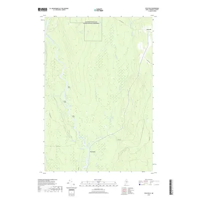
2018 Map of Stacyville
USGS Topo · Published 2018About this map
The Katahdin Woods and Waters National Monument dominates the northern reaches of this landscape, preserving a vast corridor of Maine timberland and riparian ecosystems. The East Branch Penobscot River carves through the western section, characterized by distinctive features like Whetstone Falls, Big Eddy, and various river islands including Deer Island and the Twin Islands. The terrain is defined by a complex network of logans—quiet backwaters such as Priest Logan and Beer Logan—that suggest a long history of river-based recreation and logging.
Find a feature on this map
35 named features on this map. Tap any name to fly to it.
Don’t see what you’re looking for? This feature index may not catch every label — zoom into the map to look around manually.
Map Details
Editions of this 2018 Stacyville Map
This is the sole edition of this map. No revisions or reprints were ever made.
Other maps of this area

1940 · Sherman
USGS Topo · 1:62,500

1940 · Mattawamkeag
USGS Topo · 1:62,500

1942 · Mattawamkeag
USGS Topo · 1:62,500

1942 · Sherman
USGS Topo · 1:62,500

1951 · Millinocket
USGS Topo · 1:62,500

1953 · Stacyville
USGS Topo · 1:62,500

1954 · Millinocket
USGS Topo · 1:250,000

1958 · Millinocket
USGS Topo · 1:250,000

1960 · Millinocket
USGS Topo · 1:250,000
1975 · Mattawamkeag NW
USGS Topo · 1:24,000
Featured Places
- Stacyville, ME
- T3 R7 WELS, ME
- Herseytown Township, ME
- Hay Brook, Soldiertown Township
- Grindstone Township, ME