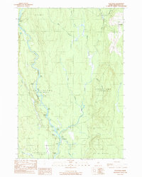
1989 Map of Stacyville
USGS Topo · Published 1989About this map
The East Branch Penobscot River defines the western corridor of this Maine township map, winding through a complex of riverine features including Big Eddy, Twin Islands, and several logans—a local term for still-water inlets. The settlement of Stacyville anchors the northeast corner, where a local Cem reflects the community's roots near the borders of Herseytown and Soldiertown.
Find a feature on this map
31 named features on this map. Tap any name to fly to it.
Don’t see what you’re looking for? This feature index may not catch every label — zoom into the map to look around manually.
Map Details
Editions of this 1989 Stacyville Map
This is the sole edition of this map. No revisions or reprints were ever made.
Other maps of this area

1940 · Sherman
USGS Topo · 1:62,500

1940 · Mattawamkeag
USGS Topo · 1:62,500

1942 · Mattawamkeag
USGS Topo · 1:62,500

1942 · Sherman
USGS Topo · 1:62,500

1951 · Millinocket
USGS Topo · 1:62,500

1953 · Stacyville
USGS Topo · 1:62,500

1954 · Millinocket
USGS Topo · 1:250,000

1958 · Millinocket
USGS Topo · 1:250,000

1960 · Millinocket
USGS Topo · 1:250,000
1975 · Mattawamkeag NW
USGS Topo · 1:24,000
Featured Places
- Stacyville, ME
- Hay Brook, Soldiertown Township
- T3 R7 WELS, ME
- Soldiertown Township, ME
- Grindstone Township, ME